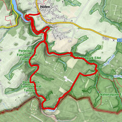
Durchs Trôs-Maret-Tal – Auf Bergpfaden am Fuße des Hohen Venns

Escursionismo
- Descrizione rapida
-
Eine kurze aber sehr reizvolle und stellenweise anspruchsvolle Wanderung am Fuße des Hohen Venns. Der Abschnitt durch das Trôs-Marets-Schluchttal ist im Herbst und Frühjahr besonders abenteuerlich und beeindruckend.
- Difficoltà
-
intermedio
- Valutazione
-
- Percorso
-
Ferme Libert0,0 kmFerme Libert8,9 km
- La stagione migliore
-
genfebmaraprmaggiulugagosetottnovdic
- Punto più alto
- 539 m
- Destinazione
-
Parkplatz Ferme Libert
- Profilo altimetrico
-
 © outdooractive.com
- Autore
-
Il tour Durchs Trôs-Maret-Tal – Auf Bergpfaden am Fuße des Hohen Venns è utilizzato da outdooractive.com fornito.
GPS Downloads


Info generali
Punto di ristoro
Flora
Altri tour nelle regioni
-
Eifel/ Rheinland-Pfalz
1056
-
Hohes Venn
601
-
Malmedy
116