The Wild W's: Col du Pillon - Kandersteg

Sciescursionismo

© Destination Gstaad - Destination Gstaad / Melanie Uhkoetter

- Descrizione rapida
-
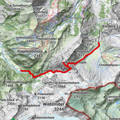
The tour of several days leads the ski tourer through the most attractive part of the western Bernese Oberland. It starts in the Diablerets massif and leads over the two famous peaks Wildhorn and Wildstrubel. On the tour you will be rewarded with an overwhelming view of the nearby four-thousand-meter peaks of the Valais. The tour lead from hut to hut and require alpine experience.
- Difficoltà
-
difficile
- Valutazione
-
- Percorso
-
Col du Sanetsch (2.252 m)4,1 kmArpelistock (3.035 m)7,9 kmGeltenhütte SAC10,9 kmMont Pucel (3.054 m)17,9 kmWildhorn (3.247 m)18,8 kmCabane du Wildhorn (2.303 m)22,6 kmWildstrubelhütte (2.793 m)31,6 kmWisshorelücke (2.851 m)32,1 kmWildstrubel (3.244 m)37,7 kmMittelgipfel (3.242 m)38,7 kmLämmerenhütte43,0 kmRote Totz Lücke45,1 km
- La stagione migliore
-
agosetottnovdicgenfebmaraprmaggiulug
- Punto più alto
- 3.240 m
- Destinazione
-
Kandersteg (1198 M.a.s.l)
- Profilo altimetrico
-
 © outdooractive.com

-

-
AutoreIl tour The Wild W's: Col du Pillon - Kandersteg è utilizzato da outdooractive.com fornito.
GPS Downloads


Info generali
Punto di ristoro
Promettente
Altri tour nelle regioni