Dem Illweg entlang

Logo Dem Illweg entlang
Dati percorsi
5,93km
662 - 697m
Distanz
40hm
47hm
L'ascesa
01:30h
 
Durata
Descrizione rapida

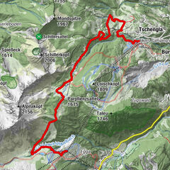
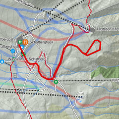
Ortszentrum Tschagguns - A.-Jochum-Weg - Illweg - Aktivpark Montafon - Bödmenstein Steg - Illweg - Parkplatz Aktivpark Montafon - Illweg - A.-Jochum-Weg - Ortszentrum Tschagguns

Difficoltà
facile
Valutazione
Tecnica
Forma fisica
Panorama
Avventura / Esperienza
Percorso
Tschagguns
0,2 km
In der Au
0,2 km
Tschagguns
5,7 km

La stagione migliore
ago
set
ott
nov
dic
gen
feb
mar
apr
mag
giu
lug
Punto più alto
697 m
Destinazione

Ortszentrum Tschagguns

Profilo altimetrico

Autore
Il tour Dem Illweg entlang è utilizzato da outdooractive.com fornito.

Valutazione complessiva

5

0

%

4

0

%

3

0

%

2

0

%

1

0

%

Errore
Si è verificato un errore. Si prega di riprovare.
Grazie per la vostra recensione

La valutazione è stata cancellata

GPS Downloads
  • GPX GPS Exchange Format (XML)
  • KML Google Earth, Google Maps
Codici di download QR per telefoni cellulari

Info generali

Punto di ristoro
Altri tour nelle regioni

Tour popolari della zona

High altitude hiking trail | Brand

intermedio Escursioni invernali
4,77km | 180hm | 02:00h

Alte Statt Weg | Brandnertal

intermedio Escursioni invernali
9,86km | 243hm | 03:30h

Lech - Zug

facile Escursioni invernali
6,96km | 108hm | 00:30h

Schafbergplateau

intermedio Escursioni invernali
1,52km | 99hm | 00:45h