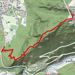
Dati percorsi
3,52km
572 - 842m
Distanz
258hm
L'ascesa
01:30h
 
Durata
Valutazione
Tecnica
Forma fisica
Panorama
Avventura / Esperienza
Punto di partenza

Zillerbrücke - Zellbergeben

Percorso
Zell am Ziller (575 m)
Sankt Josefs Kapelle
0,5 km
Herz-Jesu Kapelle
2,3 km
Zellbergeben
3,5 km


Punto più alto
842 m

Riposo/Ritiro

Gasthof Schulhaus


5,0
Valutazione complessiva

5

100

%

4

0

%

3

0

%

2

0

%

1

0

%

GPS Downloads
  • GPX GPS Exchange Format (XML)
  • KML Google Earth, Google Maps
Codici di download QR per telefoni cellulari

Condizioni dei sentieri

Asfalto
Ghiaia
Prato
Foresta
Roccia
Esposta
Altri tour nelle regioni

Tour popolari della zona

Ahornspitze

intermedio Escursionismo
9,93km | 1004hm | 05:15h

Loassattel - Kuhmesser - Kellerjoch - Kellerjoch Kapelle - Hocheben...

intermedio Escursionismo
8,7km | 605hm | 03:00h

Bergtour: Gerlossteinwand (2.166 m)

intermedio Escursionismo
5,83km | 523hm | 03:30h

Steinerkogl

intermedio Escursionismo
2,26km | 532hm | 01:30h