Inverno
Estate
Meteo
Webcam
Alloggi
Tour
Cronologia delle ricerche
Suggerimenti per la ricerca
Nessun risultato trovato
Ricerca
Tour
Casa
Estate Österreich
Stiria
Tour
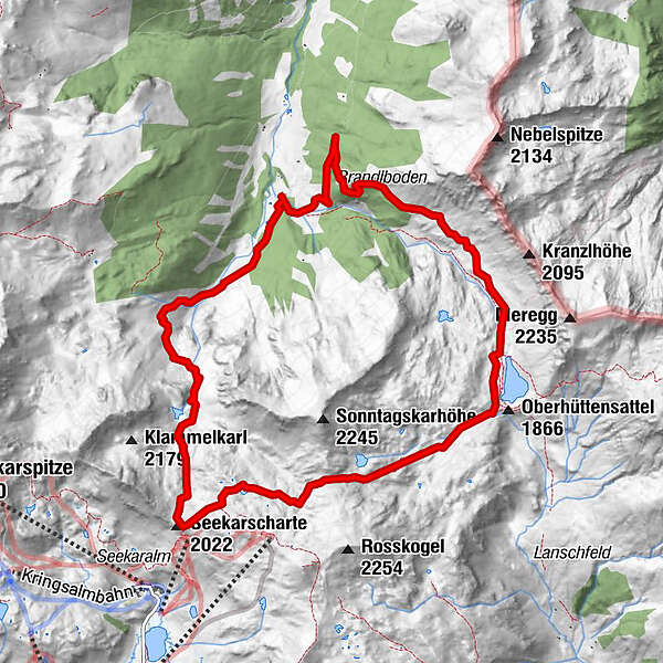
Vögeialm - Seekarscharte - Oberhüttensee
Regioni
Meteo
Webcam
Tour
Attrazioni
Laghi balneabili
Alloggi
Offerte
Fornitore di sport
Eventi
Stazioni sciistici
Sci di fondo
Snow parks
Vögeialm - Seekarscharte - Oberhüttensee
Escursionismo
Segnalibro
Mappa
mostra
nascondersi
Stampa
Dati percorsi
11,5
km
1.383 - 2.084
m
Distanz
683
hm
701
hm
L'ascesa
02:55
h
Durata
Birgit.Kaiser
creato am 09.08.2016
3.452
Chiamate
Difficoltà
difficile
Punto più alto
2.084 m
3,0
Scrivi una recensione
Valutazione complessiva
5
0
%
4
0
%
3
100
%
2
0
%
1
0
%
Valutazioni
3,0
(1)
0 Commenti
Scrivi una recensione
Errore
Si è verificato un errore. Si prega di riprovare.
Grazie per la vostra recensione
La valutazione è stata cancellata
Rapporto sul tour
GPS Downloads
GPX
GPS Exchange Format (XML)
KML
Google Earth, Google Maps
Codici di download QR per telefoni cellulari
Vögeialm - Seekarscharte - Oberhüttensee
Codici QR - Scarica il tour per i telefoni cellulari
GPX
KML
Altri tour nelle regioni
Katschberg Lieser-Maltatal
2555
Obertauern
1640
Untertauern
504
Tour popolari della zona
Faulkogel
difficile
Escursionismo
15,9
km |
1490
hm |
06:24
h
Steirische and Lungauer Kalkspitze summits via Kranzl
difficile
Escursionismo
10,91
km |
926
hm |
05:10
h
Drei-Seen-Wanderung (Steirischer Bodensee - Hüttensee - Obersee)
intermedio
Escursionismo
4,29
km |
591
hm |
04:00
h
Filzmoos: Rötelstein (Rettenstein)
Escursionismo
9,5
km |
895
hm |
05:00
h
Nessuna voce trovata.
La ricerca non è attualmente disponibile.
Si prega di affinare la ricerca.
Risultati della ricerca locale
(<= 25km)
Altri risultati di ricerca
(> 25km)
%count% Risultati della ricerca
%name%
%type%
%elevation%
%population%
%lpButton%