"alpannonia" - feeder: Wenigzell - St. Jakob im Walde - Hochwechsel


© Oststeiermark Tourismus - Birgit Kandlbauer

© Oststeiermark Tourismus - Birgit Kandlbauer

© Oststeiermark Tourismus - Tourismusverband Oststeiermark

© Oststeiermark Tourismus - TV Jofglland-Waldheimat

- Descrizione rapida
-
From the UNESCO World Heritage site of Semmering or the high-altitude health resort of Fischbach to the edge of the Pannonian plain near Köszeg, a path full of variety and attractions of nature leads: alpannonia®.
Or you can start the alpannonia trail in the fairytale village of Wenigzell. From there, the "power trail" continues to the neighboring community of St. Jakob im Walde. Across the hilly landscape, the trail then continues to the Hochwechsel. From there you can then join the main alpannonia trail.
- Difficoltà
-
difficile
- Valutazione
-
- Percorso
-
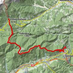
WenigzellGasthaus Kristoferitsch0,0 kmGH Lueger5,9 kmSt. Jakob im Walde6,2 kmPfarrkirche Hl. Jakobus der Ältere6,3 kmKaltenegg7,5 kmBühlhofer Höhe11,4 kmBlasenkogel (1.313 m)12,8 kmBärengrube13,4 kmRabl-Kreuz-Hütte18,1 kmKaltwiesen Hütte20,2 kmHochwechsel (1.743 m)24,3 kmWetterkoglerhaus24,3 km
- La stagione migliore
-
genfebmaraprmaggiulugagosetottnovdic
- Punto più alto
- 1.733 m
- Destinazione
-
Wetterkoglerhaus on the Hochwechsel
- Profilo altimetrico
-


- Autore
-
Il tour "alpannonia" - feeder: Wenigzell - St. Jakob im Walde - Hochwechsel è utilizzato da outdooractive.com fornito.
GPS Downloads


Info generali
Punto di ristoro
Promettente
Altri tour nelle regioni
-
Hochsteiermark
4066
-
Joglland - Waldheimat
1506
-
St. Jakob im Walde
335