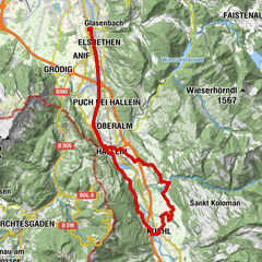
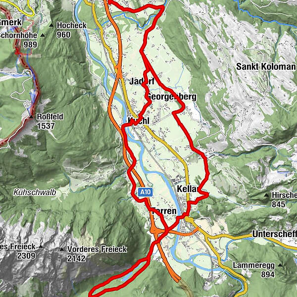
Bluntautal Route ab Bad Vigaun (Bad Vigaun-Kuchl-Golling-Bluntautal)

Bicicletta
© Tourismusverband Golling

- Descrizione rapida
-
Gemütliche Radtour von Bad Vigaun über Kuchl nach Golling zum schönen Ausflugsziel Bluntautal. Über Kuchl wieder retour nach Bad Vigaun.
- Difficoltà
-
facile
- Valutazione
-
- Percorso
-
Zum RudiNeuwirtVigaun0,0 kmBad Vigaun0,1 kmBrettstein (500 m)1,3 kmUnterlangenberg4,2 kmGeorgenberg5,9 kmKellau10,0 kmGolling an der Salzach11,8 kmSteghof13,2 kmGasthof Bärenwirt16,4 kmSteghof20,1 kmTorren21,0 kmKuchl25,8 kmSeverinsiedlung I27,0 kmGasthof Jadorferwirt27,2 kmJadorf27,3 kmUnterlangenberg28,2 kmBrettstein (500 m)31,3 kmBad Vigaun32,7 kmVigaun32,7 kmZum Rudi32,8 kmNeuwirt32,8 km
- La stagione migliore
-
genfebmaraprmaggiulugagosetottnovdic
- Punto più alto
- 509 m
- Destinazione
-
Dorfplatz Bad Vigaun
- Profilo altimetrico
-

- Autore
-
Il tour Bluntautal Route ab Bad Vigaun (Bad Vigaun-Kuchl-Golling-Bluntautal) è utilizzato da outdooractive.com fornito.
GPS Downloads


Info generali
Punto di ristoro
Altri tour nelle regioni