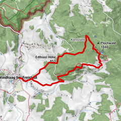
Grenzlandweg bei Windhaag

Logo Grenzlandweg bei Windhaag
Dati percorsi
11,27km
644 - 845m
Distanz
196hm
228hm
L'ascesa
02:49h
 
Durata
Descrizione rapida

Reisepass nicht vergessen!

Valutazione
Tecnica
Forma fisica
Panorama
Avventura / Esperienza
Percorso
Gasthaus Wieser
Gasthaus Sengstschmied
Windhaag bei Freistadt (723 m)
0,0 km
Pfarrkirche Windhaag
0,1 km
Freiwalddorf
0,9 km
Pieberschlag
1,5 km
Gasthof zum Waldlehrpfad
1,5 km
Panoramablick
2,2 km
Gasthof Pammer
4,5 km
Mardetschlag
4,8 km
Hammern
6,7 km
Zettwing
7,3 km
Mairspindt
9,8 km
Windhaag bei Freistadt (723 m)
11,2 km
Punto più alto
845 m

3,7
Valutazione complessiva

5

67

%

4

0

%

3

0

%

2

0

%

1

33

%

GPS Downloads
  • GPX GPS Exchange Format (XML)
  • KML Google Earth, Google Maps
Codici di download QR per telefoni cellulari
Altri tour nelle regioni
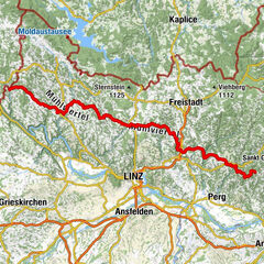
Tour popolari della zona

Mühlviertler Mittellandweg 150er

intermedio Escursionismo
124,09km | 3256hm | 40:00h

10 Mühlenweg Reichenthal, Oberösterreich

facile Escursionismo
14,3km | 172hm | 04:00h

SternGartl Blick lookout tower R4

intermedio Escursionismo
7,75km | 113hm | 02:12h

W1: Waschenberg

intermedio Escursionismo
9,83km | 354hm | 03:13h