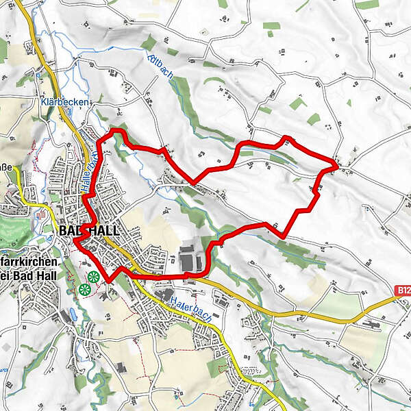
12 Waldandacht Rundwanderweg

Logo 12 Waldandacht Rundwanderweg
Dati percorsi
10,13km
348 - 407m
Distanz
128hm
130hm
L'ascesa
02:45h
 
Durata
Descrizione rapida

Kulinarisch interessanter Rundweg mit Unterkunfts- und Verpflegungsmöglichkeit

Difficoltà
facile
Valutazione
Tecnica
Forma fisica
Panorama
Avventura / Esperienza
Punto di partenza

Eduard-Bach-Str.(Forum Hall)

Percorso
Bad Hall
Ortmühle
2,5 km
Großmengersdorf
4,6 km
Landgasthaus Bachmayr
4,7 km
Mostheuriger Bayer
7,2 km
Kleinmengersdorf
7,2 km
Bad Hall
9,9 km

La stagione migliore
gen
feb
mar
apr
mag
giu
lug
ago
set
ott
nov
dic
Punto più alto
407 m
Destinazione

Eduard-Bach-Str.(Forum Hall)


Link
https://www.badhall.at/die-region-erleben/sport...

Valutazione complessiva

5

0

%

4

0

%

3

0

%

2

0

%

1

0

%

Errore
Si è verificato un errore. Si prega di riprovare.
Grazie per la vostra recensione

La valutazione è stata cancellata

GPS Downloads
  • GPX GPS Exchange Format (XML)
  • KML Google Earth, Google Maps
Codici di download QR per telefoni cellulari
Altri tour nelle regioni

Tour popolari della zona

Wanderung auf die Gradnalm

facile Escursionismo
11,27km | 666hm | 03:30h

Hohe Dirn über Hintsteinrunde

facile Escursionismo
6,77km | 418hm | 01:59h

Großer und kleiner Landsberg

facile Escursionismo
6,16km | 358hm | 02:54h

Schoberstein

facile Escursionismo
3,33km | 599hm | 03:00h