© Verein Mühlviertler Granitland


- Descrizione rapida
-
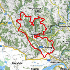
This route leads from the lowest to the highest point of the Granite Land South - from the Danube to the Gis.
- Valutazione
-
- Percorso
-
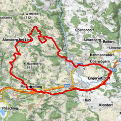
Ottensheim0,3 kmAmberg5,3 kmGramastetten8,2 kmGasthaus zur Gis15,9 kmLichtenberg19,6 kmLandgasthaus Holzpoldl20,7 kmNeulichtenberg20,7 kmKoglerauer Spitz (685 m)24,0 kmKöglerhof24,4 kmDürnberg27,9 kmGuckerstein28,2 kmGasthaus Dürnberg30,8 km
- La stagione migliore
-
genfebmaraprmaggiulugagosetottnovdic
- Punto più alto
- 884 m
- Profilo altimetrico
-


- Autore
-
Il tour MTB - Danube GIS circuit è utilizzato da outdooractive.com fornito.
GPS Downloads


Info generali
Punto di ristoro
Promettente
Altri tour nelle regioni
-
Mühlviertel
194
-
Linz & Region Linz
95
-
Eidenberg
39