© Oberösterreich Tourismus/Mühlviertler Alm Freistadt/Moritz Ablinger

© Oberösterreich Tourismus/Mühlviertler Alm Freistadt/Moritz Ablinger

© Oberösterreich Tourismus/Mühlviertler Alm Freistadt/Moritz Ablinger

© TVB Mühlviertler Alm

- Descrizione rapida
-
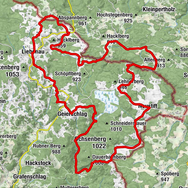
The mountain bike route is the connecting route to the mountain bike trail network of the Waldviertel. Coming from north of Karlstift, the route leads into the Liebenau municipality. Afterwards, you will continue on to the Tannenmoor/Rubenerteich (Rubenerteich moor pond) and then to the finishing point at the Moserwirt (Moserwirt Inn).
- Difficoltà
-
intermedio
- Valutazione
-
- Percorso
-
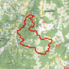
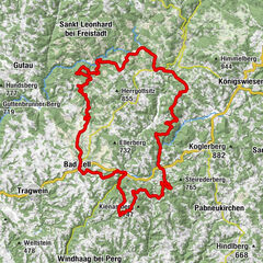
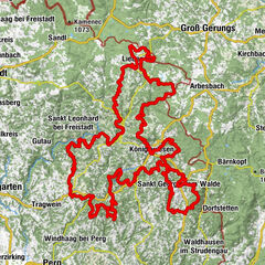
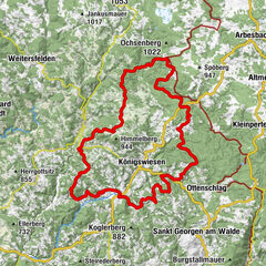
Liebenau (970 m)0,0 kmHotel Rockenschaub (1.000 m)0,0 kmGeierschlag5,0 kmRuben9,0 kmGasthaus Moserwirt11,5 kmLeopoldstein13,8 kmGasthaus Pfeiffer18,2 kmNeustift18,4 kmKienau20,8 kmOrtskapelle21,7 kmAntenfeinhöfe24,6 kmRote Lacke26,7 kmSchanz34,5 kmIm Kammbach36,2 kmGasthaus Gattringer38,8 kmLiebenau (970 m)39,0 kmHotel Rockenschaub (1.000 m)39,0 km
- La stagione migliore
-
genfebmaraprmaggiulugagosetottnovdic
- Punto più alto
- 971 m
- Profilo altimetrico
-


- Autore
-
Il tour Liebenau route no. M5 è utilizzato da outdooractive.com fornito.
GPS Downloads


Altri tour nelle regioni
-
Waldviertel
169
-
Mühlviertler Alm Freistadt
120
-
Liebenau
30