Inverno
Estate
Tempo
Webcams
Alloggi
Tour
Cronologia delle ricerche
Suggerimenti per la ricerca
Nessun risultato trovato
Ricerca
Tour
Casa
Estate Österreich
Bassa Austria
Tour
Hahnkreuzrunde
Regioni
Meteo
Webcam
Tour
Attrazioni
Laghi balneabili
Alloggi
Offerte
Fornitore di sport
Eventi
Stazioni sciistici
Sci di fondo
Snow parks
Hahnkreuzrunde
Escursionismo
Segnalibro
Mappa
mostra
nascondersi
Stampa
Dati percorsi
5,68
km
296 - 338
m
Distanz
69
hm
70
hm
L'ascesa
01:25
h
Durata
Stefan Offenthaler
creato am 28.03.2020
896
Chiamate
Valutazione
Tecnica
Forma fisica
Panorama
Avventura / Esperienza
Percorso
Wolfpassing
village
0,6 km
Knolling
hamlet
4,2 km
Punto più alto
338 m
1,7
Scrivi una recensione
Valutazione complessiva
5
0
%
4
0
%
3
33
%
2
0
%
1
67
%
Valutazioni
1,7
(3)
0 Commenti
Scrivi una recensione
Errore
Si è verificato un errore. Si prega di riprovare.
Grazie per la vostra recensione
La valutazione è stata cancellata
Rapporto sul tour
GPS Downloads
GPX
GPS Exchange Format (XML)
KML
Google Earth, Google Maps
Codici di download QR per telefoni cellulari
Hahnkreuzrunde
Codici QR - Scarica il tour per i telefoni cellulari
GPX
KML
Altri tour nelle regioni
Mostviertel
2454
Eisenstraße Niederösterreich
918
Steinakirchen am Forst
108
Tour popolari della zona
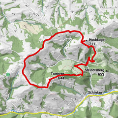
Hochkogel, Randegg, NÖ
facile
Escursionismo
11,17
km |
335
hm |
03:00
h
Auf den Prochenberg
intermedio
Escursionismo
12,04
km |
680
hm |
03:30
h
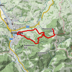
Auf den Blassenstein
facile
Escursionismo
8,3
km |
462
hm |
02:30
h
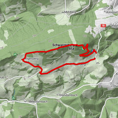
Schwarzenberg
facile
Escursionismo
4,54
km |
261
hm |
01:09
h
Nessuna voce trovata.
La ricerca non è attualmente disponibile.
Si prega di affinare la ricerca.
Risultati della ricerca locale
(<= 25km)
Altri risultati di ricerca
(> 25km)
%count% Risultati della ricerca
%name%
%type%
%elevation%
%population%
%lpButton%