© Retzer Land / Himml

© Retzer Land

© Retzer Land

© Retzer Land

© Retzer Land / Bartl

© Retzer Land / Himml


- Descrizione rapida
-
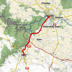
Start / Ziel: Retz
- Difficoltà
-
facile
- Valutazione
-
- Percorso
-
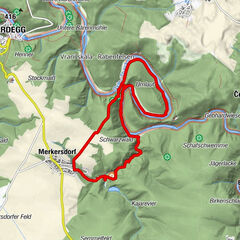
RetzSetzberg4,2 kmRetz5,9 km
- La stagione migliore
-
genfebmaraprmaggiulugagosetottnovdic
- Punto più alto
- 317 m
- Profilo altimetrico
-


- Autore
-
Il tour Weinwanderweg Retz - Immer den Reben nach è utilizzato da outdooractive.com fornito.
GPS Downloads


Info generali
Punto di ristoro
Altri tour nelle regioni
-
Weinviertel
943
-
Retzer Land
261
-
Retz
108