© Unbekannt


- Descrizione rapida
-
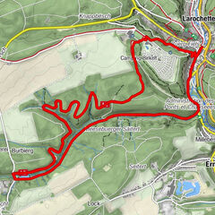
Passing through the valley of the Kielbaach, this hilly trail will take you to the top of the Juckelsbësch plateau, across field and forests and along the course of the Riedelbaach stream before reaching the starting point Thillsmillen via the valley of the Mamer.
- Difficoltà
-
intermedio
- Valutazione
-
- Percorso
-
Thillsmillen0,1 km
- La stagione migliore
-
genfebmaraprmaggiulugagosetottnovdic
- Punto più alto
- 351 m
- Destinazione
-
Thilsmillen
- Profilo altimetrico
-
 © outdooractive.com
- Autore
-
Il tour Auto-pédestre trail Mamer I è utilizzato da outdooractive.com fornito.
GPS Downloads


Altri tour nelle regioni