Inverno
Estate
Meteo
Webcam
Alloggi
Tour
Cronologia delle ricerche
Suggerimenti per la ricerca
Nessun risultato trovato
Ricerca
Tour
Casa
Estate Österreich
Carinzia
Tour
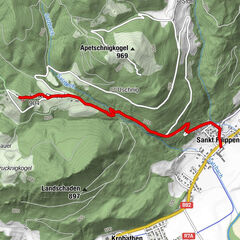
Norischer Panoramaweg
Regioni
Meteo
Webcam
Tour
Attrazioni
Laghi balneabili
Alloggi
Offerte
Fornitore di sport
Eventi
Stazioni sciistici
Sci di fondo
Snow parks
Norischer Panoramaweg
Escursionismo
Segnalibro
Mappa
mostra
nascondersi
Stampa
Dati percorsi
5
km
757 - 912
m
Distanz
237
hm
93
hm
L'ascesa
04:00
h
Durata
eberstein
3.916
Chiamate
Punto più alto
912 m
5,0
Scrivi una recensione
Valutazione complessiva
5
100
%
4
0
%
3
0
%
2
0
%
1
0
%
Valutazioni
5,0
(1)
0 Commenti
Scrivi una recensione
Errore
Si è verificato un errore. Si prega di riprovare.
Grazie per la vostra recensione
La valutazione è stata cancellata
Rapporto sul tour
GPS Downloads
GPX
GPS Exchange Format (XML)
KML
Google Earth, Google Maps
Codici di download QR per telefoni cellulari
Norischer Panoramaweg
Codici QR - Scarica il tour per i telefoni cellulari
GPX
KML
Altri tour nelle regioni
Mittelkärnten
1380
Brückl
135
Tour popolari della zona
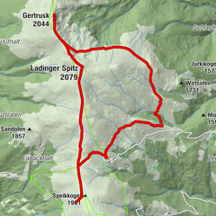
Gertrusk-Ladinger Spitz-Grosser Sauofen
intermedio
Escursionismo
13,58
km |
565
hm |
03:17
h
Klippitztörl auf den Hohenwart
facile
Escursionismo
3,24
km |
165
hm |
02:00
h
Wanderung Christofberg
facile
Escursionismo
2,93
km |
400
hm |
01:00
h
Klippitztörl: Rundwanderung
intermedio
Escursionismo
10,06
km |
317
hm |
03:30
h
Nessuna voce trovata.
La ricerca non è attualmente disponibile.
Si prega di affinare la ricerca.
Risultati della ricerca locale
(<= 25km)
Altri risultati di ricerca
(> 25km)
%count% Risultati della ricerca
%name%
%type%
%elevation%
%population%
%lpButton%