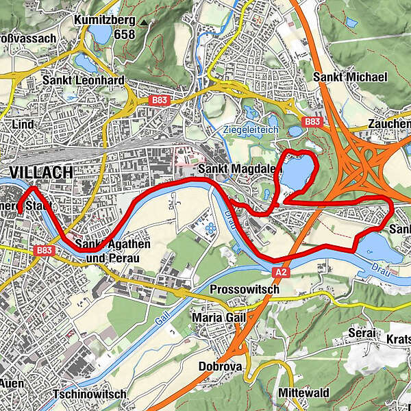
Villach - St.Ulrich/Silbersee

Logo Villach - St.Ulrich/Silbersee
Dati percorsi
10,71km
485 - 505m
Distanz
56hm
L'ascesa
03:00h
 
Durata
Descrizione rapida

Ebene Strecke, leichte Steigung
Gehzeit je nach Routenwahl zwischen 3 und 4 Stunden

Valutazione
Tecnica
Forma fisica
Panorama
Avventura / Esperienza
Punto di partenza

Villach Rathausplatz

Percorso
Innere Stadt
0,1 km
Villaco (501 m)
0,4 km
Wasenboden
1,5 km
St. Magdalen
3,6 km
Silbersee Stub`n
6,4 km
Gasthof Hopf
10,1 km

Punto più alto
505 m

Riposo/Ritiro

Silberseeranch, Gasthof zur Post bzw. Gasthof Hofer in St. Magdalen


3,0
Valutazione complessiva

5

0

%

4

0

%

3

100

%

2

0

%

1

0

%

GPS Downloads
  • GPX GPS Exchange Format (XML)
  • KML Google Earth, Google Maps
Codici di download QR per telefoni cellulari

Condizioni dei sentieri

Asfalto
Ghiaia
Prato
Foresta
Roccia
Esposta

Tour popolari della zona

Mirnock vom Osten

facile Escursionismo
8,82km | 627hm | 04:30h

Dobratsch

Escursionismo
4,54km | 509hm | 03:30h

Mittagskogel über Bertahütte

difficile Escursionismo
4,21km | 953hm | 05:45h

Mirnock Rundweg

intermedio Escursionismo
9,3km | 890hm | 05:00h