© Hohe Tauern - die Nationalpark-Region in Kärnten Tourismus GmbH - Tanja Weiß-Thalmann

© Hohe Tauern - die Nationalpark-Region in Kärnten Tourismus GmbH - Tanja Weiß-Thalmann
Dati percorsi
9,01km
1.784
- 2.250m
499hm
489hm
04:00h

- Descrizione rapida
-
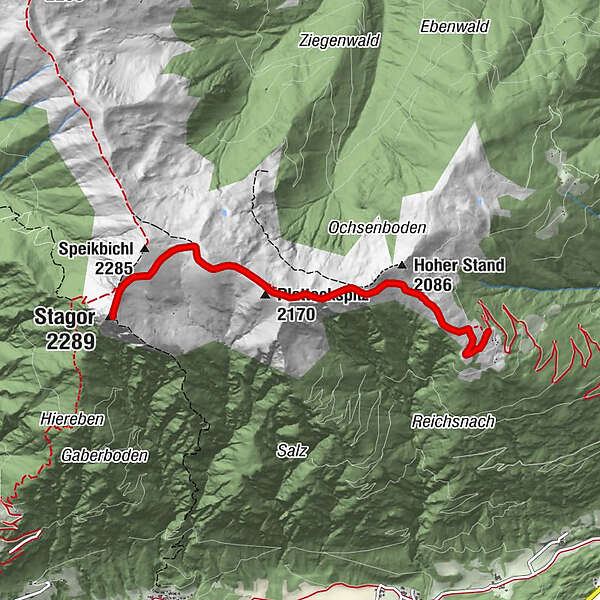
Eine aussichtsreiche und einsame Bergtour verspricht die Wanderung auf den Stagor.
- Difficoltà
-
intermedio
- Valutazione
-
- Percorso
-
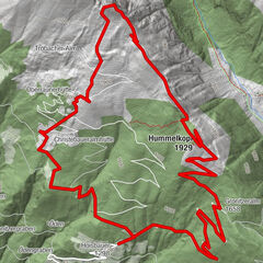
Törl (2.052 m)1,8 kmFalkkofel2,3 kmPlatteckspitz (2.170 m)2,6 kmStagor (2.289 m)4,4 kmPlatteckspitz (2.170 m)6,3 kmFalkkofel6,5 kmTörl (2.052 m)7,2 km
- La stagione migliore
-
genfebmaraprmaggiulugagosetottnovdic
- Punto più alto
- 2.250 m
- Destinazione
-
Gipfel Stagor
- Profilo altimetrico
-

- Autore
-
Il tour Stagor è utilizzato da outdooractive.com fornito.
GPS Downloads


Info generali
Promettente
Altri tour nelle regioni