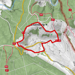
W54 Panoramaweg (Oberschützen, Mariasdorf, Neustift, Jormannsdorf)

Escursionismo


- Descrizione rapida
-
W 54 - der Wander- und Nordic Walking Weg der Lauf- und Walkingarena
- Difficoltà
-
intermedio
- Valutazione
-
- Percorso
-
OberschützenHeurigen Unger0,5 kmMariasdorf3,0 kmMostschank Karner3,1 kmSonnleiten4,3 kmGasthof Koller5,3 kmNeustift bei Schlaining5,4 kmJormannsdorf7,7 kmFilialkirche hl. Anna8,1 kmOberschützen9,2 kmPizza Bella9,3 km
- La stagione migliore
-
genfebmaraprmaggiulugagosetottnovdic
- Punto più alto
- 496 m
- Destinazione
-
Hauptplatz Oberschützen
- Profilo altimetrico
-


- Autore
-
Il tour W54 Panoramaweg (Oberschützen, Mariasdorf, Neustift, Jormannsdorf) è utilizzato da outdooractive.com fornito.
GPS Downloads


Info generali
Punto di ristoro
Culturale/Storico
Promettente
Altri tour nelle regioni
-
Wiener Alpen
3048
-
Bucklige Welt - Wiener Alpen
792
-
Mariasdorf
120