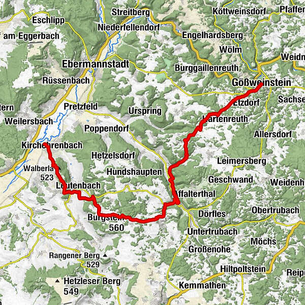
Fränkische Schweiz – Von Kirchehrenbach über Egloffstein nach Gößweinstein

Escursionismo
- Descrizione rapida
-
Wanderzeit:
-
Wandertag: Kirchehrenbach – Egloffstein etwa 15 km und 530 m Anstiege ca. 5 Std. ;
-
Wandertag: Egloffstein – Gößweinstein etwa 14 km und 330 m Anstiege ca. 4 Stunden
-
- Difficoltà
-
intermedio
- Valutazione
-
- Percorso
-
Kirchehrenbach0,3 kmSt. Bartholomäus0,3 kmSt. Walpurgis2,2 kmWalberla (513 m)2,3 kmEhrenbürg2,4 kmRodenstein (532 m)3,1 kmSchlaifhausen3,9 kmLeutenbach5,0 kmMoritzbach-Wasserfall6,3 kmSt. Moritz6,4 kmMoritzquelle6,5 kmSt. Moritz6,6 kmOrtspitz (487 m)7,3 kmBurgstein (560 m)10,2 kmHaidhof (535 m)10,5 kmThuisbrunn12,7 kmEgloffstein14,4 kmZur Post14,7 kmSchlossblick16,4 kmMostviel (347 m)16,4 kmÄpfelbach17,7 kmSchlehenmühle18,5 kmZum Boderschmo18,6 kmSt. Erhard20,4 kmWichsenstein20,5 kmHeide21,9 kmKapelle für die Kriegsopfer26,9 kmBasilika zur Heiligsten Dreifaltigkeit27,5 kmGößweinstein (457 m)27,5 km
- La stagione migliore
-
genfebmaraprmaggiulugagosetottnovdic
- Punto più alto
- 553 m
- Destinazione
-
Wallfahrtskirche in Gößweinstein
- Profilo altimetrico
-
 © outdooractive.com
- Autore
-
Il tour Fränkische Schweiz – Von Kirchehrenbach über Egloffstein nach Gößweinstein è utilizzato da outdooractive.com fornito.
GPS Downloads


Info generali
Punto di ristoro
Culturale/Storico
Flora
Promettente
Altri tour nelle regioni
-
Franken
510
-
Frankenjura
373
-
Gößweinstein
138