Dati percorsi
20,9km
784
- 897m
335hm
335hm
02:40h

- Descrizione rapida
-
Leichte Halbtagestour von Schwangau zur Wieskirche und retour..
- Difficoltà
-
facile
- Valutazione
-
- Percorso
-
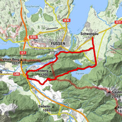
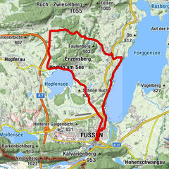
Schwangau (796 m)0,2 kmMühlberg2,2 kmRestaurant Bannwaldsee3,7 kmBayerniederhofen (799 m)8,4 kmHafenfeld9,0 kmHalblech9,9 kmTrauchgau (792 m)11,2 kmLandgasthof Post11,5 kmAchkapelle11,5 kmSt. Michael14,3 kmUnterreithen14,3 kmMarienkapelle14,8 kmOberreithen14,8 kmSchober15,5 kmResle18,4 kmGasthof Schweiger20,8 kmWieskapelle20,8 kmWies20,9 km
- La stagione migliore
-
genfebmaraprmaggiulugagosetottnovdic
- Punto più alto
- 897 m
GPS Downloads


Percorsi
Asfalto
Ghiaia
Vie di montagna
Singletrail
Trial
Traffico
Altri tour nelle regioni